Port of Ulsan
Overview
Concept of Hinterland
Hinterland is land designated and developed in accordance with Article 42 of the Harbor Act to promote value-added of ports and revitalization of the port industries while improving convenience for port customers.
Development Objective
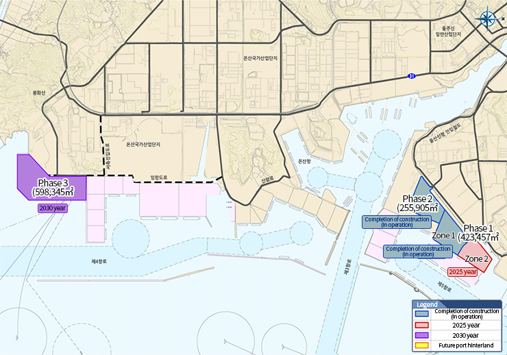
The Ulsan Port Hinterland was designated and has been notifying officially based on ‘The 4th Comprehensive Plan for Development of a Port Hinterland’ in 2022. The development of Ulsan Port Hinterland has been in the works by UPA with an objective of creating a site (area of 1,278,000 ㎡) for the purpose of supporting complex logistics and manufacturing, and the Oil Hub by 2030.
Location Status
The north port of the Oil Hub and 2 berths at northern quay wall are located at the front of the hinterland, and the accessibility to the metropolitan transportation network is convenient as it is at the center of Ulsan New Port, which is close to the Ulsan New Port Container Terminal.
Convenient access to the metropolitan transportation network using National Route 31 (Onsan-Duwang), Ulsan National Industrial Complex access road, and lead-in railroad to the New Port (2019).
Located at the core of the cutting-edge manufacturing and logistics activities in Ulsan, surrounded by industrial centers including Onsan National Industrial Complex, petrochemical complex, new industrial complex, and free trade zone to the back.
Ulsan New Port Hinterland
Address : Yongyeon-dong, Nam-gu and Ilwon, Onsan-eup, Ulju-gun, Ulsan Metropolitan City
Construction Area : 1,277,619㎡ expected by 2030 (excluding site for rail depot)
Phase 1, North Port of Ulsan New Port (Zone 1 and 2): 423,457㎡
Phase 2, North Port of Ulsan New Port (Zone 3): 255,817㎡
Phase 3, North Port of Ulsan New Port (expected): 598,34㎡
Construction Objective : To reinforce the function of supporting logistics service of the industrial complex and become a ‘local industry-leading port hinterland’ to support the Oil Hub
※ Ulsan New Port Hinterland (phase 1 and 2) is a hinterland that funded by the Ulsan Port Authority’s own resources. It differs in operation and development concept to free trade local hinterlands that are constructed with government finance with an objective of attracting foreign investment through free trade activities.
Construction Status
※ 표를 좌우로 스크롤해주세요.
| Category | Total | Phase 1 | Phase 2 | |
|---|---|---|---|---|
| Zone 1 | Zone 2 | Zone 3 | ||
| Area | 679,000㎡ | 242,000㎡ | 181,000㎡ | 256,000㎡ |
| Project Period | May 2010 ~ June. 2022 |
May 2010 ~ Feb. 2014 |
Nov. 2013 ~ June. 2022 |
Nov. 2012 ~ Apr. 2017 |
| Development Use | Integrated logistics & manufacturing Oil Hub support |
Integrated logistics & manufacturing | Oil Hub support | Integrated logistics & manufacturing |
| Project Cost () | 127.2 billion KRW | 45.1 billion KRW | 42.1 billion KRW | 40 billion KRW |
| Implementing Entity/Financing Procurement |
Ulsan Port Authority | |||
※ Development Progress (as of Feb. 1, 2013) : Zone 1 (completion in July 2014), Zone 3 (completion in April 2017), Zone 2 (37.2%)
Status of Nearby Infrastructure Construction
Current Status of Roads and Railroads
※ 표를 좌우로 스크롤해주세요.
| Implementer | Project Name | Section | Length (km) | Roads | Project Cost (billion KRW) | Project Period |
|---|---|---|---|---|---|---|
| State | National Route 31 (Onsan - Duwang) |
Sungjin Geotec - Duwang National Route 14 | 6.5 | 4 | 1,315, | Mar. 2006 - June 2014 |
| Ulsan City | New Port pier access road |
Back gate of the petrochemical complex - North Port | 8.3 | 5-6 | 651 | Apr. 2019 - Mar. 2014 |
| Ulsan City | Ulsan National Industrial Complex access road |
Cheongryang IC - Cheoyongam gate | 5.6 | 4 | 1,154 | June 2009 - Dec. 2015 |
| Ulsan City | Lead-in railroad to the New Port |
Mangyang Station, Onyang - North Port of New Port | 9.3 | Single line | 1,883 | 2014∼2019 |
Rail Depot : Area of 93,499㎡, Construction by Korea National Railway(Completed in 2022)
Roads inside the Complex : Major arterial road (width 30m), minor arterial road (width 20-25m)